So we decided to do the trip the other way around in the hopes that The San Juans/Ouray will have dried up a little.
Only one night in Grand Canyon, 5 in Moab, one in Denver and finally from the 7th until early morning on the 12th of June we will be based in Ouray and then head back down to Albuquerque for one more week before driving to NYC.
Dan, I got the app you mentioned, inRoute. It should be useful.
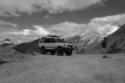
When you were in Moab what trails did you do. I remember that we both did the one in the Arches National Park, I also did Onion Creek but not much on the Sands Flats. Have you done some there? Anyone else? Besides the compos and duratracs my LR4 is stock. I did a few "********" trails just fine respecting the LR approach "as slow as possible, as fast as necessary" and all is well.
I'd like to do Fins 'n Things, Hells Revenge and such.
We might also spend an afternoon white water rafting.
This sounds like a great trip, Axel! Something your wife and you will be able to talk about for years to come. As for Moab, there are others who have more experience to me as I have just begun getting a taste for it. Here are some suggestions, though.
- Potash Rd -> Shafer Trail Switchbacks (up) -> Islands in the Sky NP -> Dead Horse State Park. Definitely explore a bit of the paved roads in Islands in the Sky. You get a very different perspective when you are on top compared to when you are down in the canyons or by the river. You could do this loop in either direction. I would probably do it in the reverse of what I just told you but that's because I prefer to go down narrow switchbacks so I can pause at each corner to see if someone is coming up and wait. This is not a terribly challenging drive. People have done it in much less capable vehicles but some have regretted trying. Probably the roughest part is the section at the bottom of the switchbacks. You can see Potash Rd from Dead Horse State Park.
- I like Hurrah Pass which is a relatively easy drive west out of Moab. You can continue on to Chicken Corners but it will take much longer and I'm not sure the view is that much better.
- If you have the time, you should explore the Needles district a bit as well. Mostly paved roads up on top but great views once you get out to the edge. From the Anticline Overlook looking to the north and down, way down, you will see the Hurrah Pass road winding along. From the Needles Overlook you can look down on the rock formations that form the Needles. Although I haven't yet had time to do this you can also drive into the bottom of the Needles district which, again, gives a wholly other perspective.
- I haven't spent any time in the Sand Flats area or that whole area east of Moab. Others will need to help you out there.
None of what I have suggested are trails which are primarily for the challenge of off roading. They are routes which are highly rated for their scenic value first and a difficult value that won't be a problem if you are alone in a stock LR4. I use the Utah Trails books, Moab Region by Massey, Wilson and Titus. It is a bit dated with respect to trail conditions but it includes scenic ratings which we have found very helpful. Those books usually provide a bit more history or other background on the trail which we find interesting. For more recent info on the trails I check the routes against the Funtreks book for Utah. They don't always match up names/routes but they are close enough.
If you get a chance to drive Utah 12 coming from the Grand Canyon I highly recommend this. And if you do I can tell you about a route that runs past Goblin State Park (off Hwy 24) and on past Temple Mountain and eventually comes out on I70. (Pics of this trail/road below.)
1 - Goblin Valley State Park. If you are familiar with the Tim Allen movie Galaxy Quest the scenes where Tim Allen fought the rock monster was filmed here. (I have kids that were in their early teens then!)
2, 3, 4, 5 - View from along Temple Mountain Rd that eventually connects to I70
BTW, the turn off of Utah 24 to Goblin Valley State Park is on a little way north of the turn off of 24 going east towards The Maze and a number of remote and challenging 4x4 trails.