Spring Break - Utah Overland Trip

Disclaimer: Links on this page pointing to Amazon, eBay and other sites may include affiliate code. If you click them and make a purchase, we may earn a small commission.

nwoods

Full Access Member
Joined
Apr 27, 2006
Posts
1,675
Reaction score
24
[FONT=Arial, Helvetica, sans-serif]Hey guys, I am making a pilgrimage of sorts, to explore the canyons and vistas of Utah in my LR3.

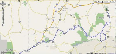
After much research and with the welcome and knowledgeable advice from the Expedition Portal forum, I think I have my plan worked out.
[/FONT][FONT=Arial, Helvetica, sans-serif]As many of you know, I call Southern California home, so [/FONT][FONT=Arial, Helvetica, sans-serif]we are going to start on the west side and work our east, ending in Moab (and thus avoiding the Easter Jeep Safari the week prior in Moab).

Day 1 - Saturday, March 22
[/FONT]
  • [FONT=Arial, Helvetica, sans-serif]Depart SoCal - drive through to Ruby's Inn near Bryce, take sunset photos of Bryce Canyon.
    [/FONT]
[FONT=Arial, Helvetica, sans-serif]Day 2
[/FONT]
  • [FONT=Arial, Helvetica, sans-serif]Sunrise photos of Bryce. Nice way to start Easter.[/FONT]
  • [FONT=Arial, Helvetica, sans-serif]Morning hike with the family[/FONT]
  • [FONT=Arial, Helvetica, sans-serif]Lunch in Bryce, or maybe hit the road and have lunch in Tropic[/FONT]
  • [FONT=Arial, Helvetica, sans-serif]Work our way east along the 12 Hwy to Boulder, stopping often I imagine[/FONT]
  • [FONT=Arial, Helvetica, sans-serif]Overnight at Boulder Lodge[/FONT]
  • [FONT=Arial, Helvetica, sans-serif]Alternate would be to camp at Calf Creek[/FONT]
Day 2 Alternate:
  • [FONT=Arial, Helvetica, sans-serif]Stop in Escalante/Grand Staircase National Monument. Take the Hole-in-the-Rock trail to Dry Fork, and explore the slot canyons of Spooky Canyon and Peek-A-Boo canyon.[/FONT]
  • [FONT=Arial, Helvetica, sans-serif]Camp at Calf Creek, and visit the waterfalls at sunset for photos.
    [/FONT]
[FONT=Arial, Helvetica, sans-serif]Day 3
[/FONT]
  • [FONT=Arial, Helvetica, sans-serif]From Boulder, take Burr Trail (road?) through Waterpocket Fold, down to Bullfrog[/FONT]
  • [FONT=Arial, Helvetica, sans-serif]Take the ferry across Halls Crossing, then take the 276 east to Natural Bridges Monument[/FONT]
  • [FONT=Arial, Helvetica, sans-serif]Head south on the 261, up Moki Dugaway, to the Valley of the Gods[/FONT]
  • [FONT=Arial, Helvetica, sans-serif]Have a meal at the famous Mexican Hat stop.
    [/FONT]
  • [FONT=Arial, Helvetica, sans-serif]Get onto the 163 east, and go up the east side of Combs Ridge, along Butler Wash Road to the 95[/FONT]
  • [FONT=Arial, Helvetica, sans-serif]Take the Arch Canyon Trail off the 95[/FONT]
  • [FONT=Arial, Helvetica, sans-serif]Camp along Arch Canyon trail[/FONT]
[FONT=Arial, Helvetica, sans-serif]Day 4 (and 5?)
[/FONT]
  • [FONT=Arial, Helvetica, sans-serif]Take a combination of trails off the 95, heading north through the Dark Canyon area towards Elephant Hil Loop.[/FONT]
  • [FONT=Arial, Helvetica, sans-serif]Possibly Cottonwood Walsh to the Cottonwood Canyon trails, to Beef Basin, to Bobby's Hole/Ruin Park trails[/FONT]
  • [FONT=Arial, Helvetica, sans-serif]To Elephant Hill Loop, and then exit east on 211[/FONT]
  • [FONT=Arial, Helvetica, sans-serif]Then north on the 191 and clean up in Moab Valley Inn[/FONT]
  • [FONT=Arial, Helvetica, sans-serif](not sure if this leg will require camping along the way, it's impossible to figure the travel time on the map for this day's journey)[/FONT]
[FONT=Arial, Helvetica, sans-serif]Day 5 (or 6)
[/FONT]
  • [FONT=Arial, Helvetica, sans-serif]Take the 70 westward towards home[/FONT]
  • [FONT=Arial, Helvetica, sans-serif]Hit the Black Dragon trails near Capitol Reef (within 1/4 mile of the 70!)[/FONT]
  • [FONT=Arial, Helvetica, sans-serif]Maybe take the Three Fingers Petroglyph trail in the same area[/FONT]
  • [FONT=Arial, Helvetica, sans-serif]Overnight in St. George[/FONT]
[FONT=Arial, Helvetica, sans-serif]Day 7
[/FONT]
  • [FONT=Arial, Helvetica, sans-serif]Vegas! then home[/FONT]
[FONT=Arial, Helvetica, sans-serif]
This is a family oriented trip. None of the trails are very difficult, though Elephant Hill sounds interesting. Everything else appears to be either paved or graded dirt road. I plan on stopping frequently for photos and to let the kids run around and rock scramble as much as possible.

I have collected lots of links to trail reports, photos, maps, etc... I have ordered some of materials from OutbackUSA, such as "Trails of the Ancient Ones" from Larry Heck. It is my hope to see Petroglyphs, Cliff Dwellings, and slot canyons.

I am casually open to having others accompany us as a Tag-a-long sort of grouping. The only thing I can promise is dust, mud, and amazing vistas.

800px-Capitol_Reef_-_Burr_Trail.jpg


[/FONT]
 

Attachments

  • Google_map-Utah-overview.jpg
    Google_map-Utah-overview.jpg
    29.8 KB · Views: 126

Lyon

Full Access Member
Joined
Feb 5, 2008
Posts
153
Reaction score
0
That sounds like an unbelievably good time!
 
Last edited:

Roverine

Full Access Member
Joined
Oct 4, 2005
Posts
165
Reaction score
0
Sounds like a great trip. You'll love the Boulder Lodge. The Burr Trail is a road. It was paved in a huge controversy in the 80's but it is very scenic still, and several good trails lead off from it if you have time (Horse and Wolverine Canyons- lots of huge trunks of petrified wood). If you are thinking of accessing Elephant Hill from Beef Basin, I assume you will come in on the Cathedral Butte trail out of the Cottonwood Canyon? That route will be a solid, long day of wheeling if you intend to get to Moab by nightfall. Nothing technical, but lots of washes and rises to traverse so it can be slow going. There are several good ruins areas along the way you'll want to explore (including an awesome 2 story turret), but that will slow you down as well. Camping on the BLM land in Beef Basin before you get to the park boundary might be advisable. Once you get to Canyonlands NP you'll need a backcountry permit and camping around Elephant Hill is beautiful but spaces are very limited (Devil's Kitchen) and get reserved early that time of year. Elephant Hill is technical, but not too tough. From what I know of your exploits form reading here-- piece of cake. Have a great time. Enjoy the Utah desert!
 
Last edited:

ChuckD

Full Access Member
Joined
Oct 10, 2007
Posts
76
Reaction score
0
Is that photo of the road down to the Colorado that starts just inside the Canyonlands NP entrance? My avatar is the sign at river's edge at the bottom of the road. A great drive if going down.

ChuckD
 

Roverine

Full Access Member
Joined
Oct 4, 2005
Posts
165
Reaction score
0
ChuckD: Do you mean the Lockhart Basin road? If so, you are right about the road to the river- Chicken Canyon, right? That is a great drive. I have only done it on mountian bike but I saw a guy drive an F-350 down there which was a feat. In the picture, the Mountains in the background look to be the Henrys and the road is the unpaved part of the Burr trail that runs through Capitol Reef NP coming off of the crest of the Waterpocket Fold looking east.
 
Last edited:

nwoods

Full Access Member
Joined
Apr 27, 2006
Posts
1,675
Reaction score
24
Roverine, thanks for the info. You seem to know the area well. One option I been considering over Boulder/Burr Road is to take Hole in the Rock and then Left Hand Collet Canyon to Smoky Mountain Road and south on the 89 back up towards Mexican Hat.

My reasons for doing so would be to explore Spooky Canyon off Dry Fork along the Hole in the Rock road.

What I can't estimate though is time. Do you have an opinion that that option might take in terms of days?
 

Roverine

Full Access Member
Joined
Oct 4, 2005
Posts
165
Reaction score
0
Roverine, thanks for the info. You seem to know the area well. One option I been considering over Boulder/Burr Road is to take Hole in the Rock and then Left Hand Collet Canyon to Smoky Mountain Road and south on the 89 back up towards Mexican Hat.

My reasons for doing so would be to explore Spooky Canyon off Dry Fork along the Hole in the Rock road.

What I can't estimate though is time. Do you have an opinion that that option might take in terms of days?

Hi Nathan: I live in Salt Lake but I have been exploring the southern Utah desert for 27 years. In fact, my first trip to that part of the world was as a passenger in a friend’s new Jeep C-J to Hole-in-the-Rock in 1980. That trip convinced me I needed a Jeep too. After my first C-J, a couple of Isuzu Troopers and a Ford Expedition, I have graduated to my LR3, which- apart from the shorter wheelbase of my primitive C-J- is the best wheeling vehicle I have owned.

As I recall, almost all of the Hole-in-the-Rock road along the Straight or “Fifty-Mile” Cliffs is graded gravel/dirt on which speeds of 50 mph are not a problem. Side routes such as Left Hand Collet Canyon are a different story. That road ascends the Fifty-Mile Cliffs onto the Kaiparowits Plateau, so it’s got to have some interesting spots. However, I have never been up on top of Kaiparowits , so I can’t be of much help about Left Hand Collet Canyon or the Smokey Mountain stretch. I did find this link about that route:
http://www.blm.gov/education/00_fieldtrip/journal0501.html:
“Soon after we left Escalante, still traveling on Highway 12, we turned right and headed south onto "Hole in the Rock" Road, a well-traveled dirt road from which you could see, looking to the West, the "Straight Cliffs" of the Kaiparowits Plateau rising up from the ground.”
“Continuing down Hole in the Rock Road, we turned right onto a not-so-well traveled road in Left Hand Collet Canyon. Chris explained that the road led up to the top of Kaiparowits Plateau, but it is a treacherous drive and even our vehicle would not make it.”

but perhaps you’ve already seen this.

I also have not hiked Spooky Gulch, but it is supposed to be a great narrows and to take about a day of hiking. http://www.redrockadventure.com/hiking/hiking_spooky_gulch.htm. Don't forget to know the weather going into a place like Spooky Gulch. As you'll be able to see when you are down there, tremendous areas of rock drain into those slot canyons and flash floods come up quickly, even if it's not raining where you are.

Obviously, the new route is longer, and you trade Spooky and ( I bet Left Hand Collet is beautiful too) for the Burr Trail (Muley Twist, Horse Canyon) and the ferry ride from Bullfrog to Hite.

Hard to estimate your time, especially with kids who will want to be outside more than in the ride, but I would guess you’ll be adding another day onto your trip, and maybe two depending how long you hike around Spooky.

Now I really want to go with you. But I already have plane tickets.
 
Last edited:

Latest posts

Members online

Forum statistics

Threads
36,719
Posts
222,740
Members
30,890
Latest member
Besi
Top